
What Is the Difference Between Field Mapping and Yield Mapping?
Modern agriculture relies heavily on accurate data to improve efficiency, manage resources, and understand how fields perform over time. Two common tools used in precision agriculture are field mapping and yield mapping. Although they are closely related, they serve different purposes and provide different types of information.
Understanding field mapping vs. yield mapping can help growers decide which data is most useful for specific management decisions. Both technologies often work together within agriculture mapping software, giving farmers a more complete view of field conditions and crop performance. When used correctly, these maps can support better planning, more precise input applications, and improved long-term decision-making.
What Is Field Mapping?
Field mapping is the process of creating a digital representation of an agricultural field and the important features located within it. A field map usually establishes geographic boundaries and provides a foundation for organizing other types of agricultural data. GPS technology, satellite imagery, drones, and farm management platforms can all contribute to the mapping process.
A basic field map may show the exact shape and acreage of a field, but more advanced maps can contain much more information. Growers can add soil sampling locations, drainage features, irrigation systems, waterways, obstacles, crop zones, and other details. These layers help farmers understand the physical characteristics of their land.
Field maps also make it easier to organize information from season to season. Instead of relying on paper records or memory, growers can store geographically referenced data in one digital system. This creates a consistent framework for analyzing changes and comparing results over time.
What Is Yield Mapping?
Yield mapping focuses specifically on measuring and displaying crop production across different areas of a field. It is commonly created using yield monitors installed on harvesting equipment. These systems record crop yield while GPS technology identifies where each measurement was collected.
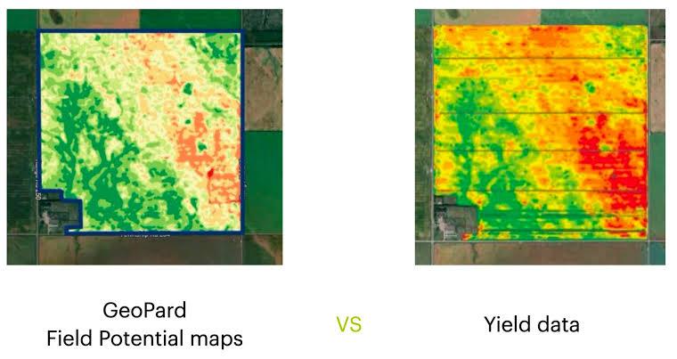
The resulting map shows variations in productivity throughout the field. Some sections may consistently produce higher yields, while others may perform below the field average. Yield maps often use different visual categories to make these patterns easier to identify.
Yield mapping can help growers determine where crops are performing well and where additional investigation may be necessary. However, a yield map usually shows what happened rather than explaining why it happened. Additional information such as soil tests, weather records, elevation data, or crop scouting observations may be required to identify the cause of yield differences.
Field Mapping vs. Yield Mapping: The Main Difference
The primary difference between field mapping vs. yield mapping is the type of information each map is designed to represent. Field mapping provides a geographic framework for the entire field, while yield mapping focuses on crop production within that framework. In simple terms, field mapping shows where things are, while yield mapping shows how much crop was produced in different locations.
Field mapping can be performed before planting, during the growing season, or after harvest. Yield mapping, by comparison, generally depends on information collected during harvest. This makes field maps useful throughout the production cycle, while yield maps are primarily used to evaluate crop performance.
The two technologies are not competing approaches. In many precision agriculture systems, yield data is simply another information layer placed on top of an existing field map.
What Information Does Field Mapping Include?
The information included in a field map depends on the farm and the purpose of the map. Some maps may contain only boundaries and acreage, while others incorporate numerous data layers. Modern agriculture mapping software makes it possible to organize these layers within a single field record.
Common field mapping information includes:
- Field boundaries
- Total acreage
- Soil sampling points
- Soil types
- Elevation and slope
- Drainage features
- Irrigation systems
- Waterways and buffer zones
- Roads and access points
- Crop varieties
- Management zones
- Previous application records
- Weed, pest, or disease observations
These details can help growers plan planting, fertilizer applications, irrigation, scouting, and other field operations. Because each piece of information is connected to a geographic location, farmers can determine where specific conditions occur.
What Information Does Yield Mapping Include?
Yield maps concentrate on crop production data collected during harvesting. A yield monitor typically measures crop flow through the harvesting equipment while GPS coordinates identify the machine’s location. Additional sensors may measure factors such as moisture content.
Depending on the equipment and software, a yield map may include:
- Crop yield by location
- Harvested acreage
- Grain moisture
- Harvest speed
- Harvest date and time
- Field productivity patterns
- High-yielding zones
- Low-yielding zones
- Average yield calculations
This information gives farmers a detailed picture of how productivity varies throughout a field. Instead of looking only at the total yield for the entire field, growers can see how specific sections performed.
How Field Mapping Supports Precision Agriculture
Field mapping provides the geographic foundation for many precision agriculture technologies. GPS-based equipment needs accurate field boundaries and location data to perform tasks such as automated steering, variable rate planting, and variable rate fertilizer application. Mapping can also support more organized scouting and recordkeeping.
For example, a grower may use a field map to record a low area that frequently experiences drainage problems. Soil sample results can then be added to the same map, along with crop scouting observations and application records. Combining these layers can help the farmer understand how different field characteristics affect crop performance.
Field maps are also useful for planning management zones. Areas with similar soil characteristics or productivity potential can be grouped together and managed differently from other sections of the field.
How Yield Mapping Supports Precision Agriculture
Yield mapping provides direct evidence of crop performance. By comparing production across a field, growers can identify patterns that might not be obvious during routine field observations. Areas that look similar during the growing season may produce substantially different yields at harvest.
One year of yield data can be informative, but multiple years are often more useful. A low-yielding area during a single season could result from temporary conditions such as excessive rainfall or localized pest pressure. If the same area performs poorly over several seasons, the pattern may indicate a more persistent limitation.
Historical yield information can support decisions involving soil sampling, drainage improvements, seed populations, fertilizer rates, and other management practices. It can also help growers determine whether previous field improvements have produced measurable results.
How Agriculture Mapping Software Connects the Two
Modern agriculture mapping software allows field maps and yield maps to be viewed together. Instead of managing separate sets of information, farmers can store multiple geographic data layers within the same system. This makes comparisons much easier.
For example, a grower can compare a yield map with a soil nutrient map. If low-yielding areas correspond with low potassium levels, additional soil testing or fertilizer adjustments may be appropriate. If nutrient levels appear adequate, the farmer can investigate other factors such as drainage, compaction, or soil texture.
Software platforms may also allow growers to compare yield information with:
- Planting maps
- Fertilizer application maps
- Soil test results
- Satellite imagery
- Elevation maps
- Irrigation records
- Crop scouting observations
- Previous management zones
Combining multiple data sources provides context that a single map cannot provide on its own.
Why Accurate Data Matters
Both field mapping and yield mapping depend on accurate data. Incorrect field boundaries, GPS errors, improperly calibrated sensors, or incomplete records can produce misleading results. Farmers should review mapping information regularly and correct obvious errors before using the data for major decisions.
Yield monitor calibration is particularly important. If the system is not calibrated properly for the crop and harvesting conditions, recorded yields may differ from actual production. Equipment manufacturers generally provide calibration procedures that should be followed throughout the harvest season.
Field maps should also be updated when boundaries or field features change. New drainage systems, removed fence lines, changed access roads, or combined fields may require updated digital records.
Using Field and Yield Maps for Management Zones
One valuable use of field and yield mapping is the creation of management zones. These zones group areas of a field that share similar characteristics or performance patterns. Farmers can then manage those areas differently instead of applying one strategy across the entire field.
Historical yield maps are especially useful for identifying stable productivity zones. An area that consistently produces above-average yields may have different input requirements than an area with limited yield potential. Field data such as soil type and elevation can help explain those differences.
Management zones may eventually be used to create variable rate prescriptions for seed, fertilizer, lime, or other inputs. The goal is to match management practices more closely with actual field conditions.
Which Mapping Method Should Farmers Use?
Choosing between field mapping and yield mapping is not usually necessary because they provide complementary information. Field mapping establishes the basic structure needed to organize farm data, while yield mapping measures crop performance. Farms interested in precision agriculture can benefit from using both.
A grower who is just beginning with digital agriculture may start by creating accurate field boundaries. Soil sampling locations, crop information, and application records can then be added. Yield data can be incorporated as suitable harvesting equipment and monitoring technology become available.
The best approach depends on the farm’s crops, equipment, management goals, and available technology. Starting with accurate, useful information is often more valuable than collecting large amounts of data without a clear purpose.
FAQ About Field Mapping and Yield Mapping
Is field mapping the same as yield mapping?
No. Field mapping creates a geographic representation of the field and its features, while yield mapping records how much crop was produced in specific locations during harvest.
Do I need a field map before creating a yield map?
A yield monitor can collect GPS-referenced data during harvest, but accurate field boundaries make it easier to organize and analyze that information. Most precision agriculture systems therefore use field maps as the foundation for yield data.
What equipment is needed for yield mapping?
Yield mapping generally requires a compatible yield monitor, GPS receiver, sensors, and harvesting equipment. Requirements vary depending on the crop and equipment manufacturer.
Can field maps include soil test results?
Yes. Soil sampling locations and laboratory results can be connected to geographic coordinates and displayed as layers within a digital field map.
How often should yield maps be created?
Yield maps can be created every harvest when compatible monitoring equipment is available. Collecting data across multiple seasons can help reveal long-term productivity trends.
Can yield maps be used to create fertilizer prescriptions?
Yes, but yield information should generally be combined with soil tests, crop requirements, and agronomic recommendations. Yield data alone may not identify the underlying reason for low or high productivity.
Does agriculture mapping software store multiple years of data?
Many agriculture mapping software platforms allow users to store and compare information from multiple seasons. Features vary by platform, so growers should select software that supports their equipment and management needs.
Building a More Complete Picture of Field Performance
Understanding field mapping vs. yield mapping is important because each method answers a different agricultural question. Field mapping identifies where field boundaries, soil characteristics, management zones, and other features are located. Yield mapping measures how crops actually perform within those locations.
Used together, these technologies provide significantly more useful information than either one alone. Agriculture mapping software can combine field boundaries, soil data, planting information, application records, and yield results into a single geographic system. This allows growers to compare conditions with outcomes and identify patterns that can guide future management.
Precision agriculture is ultimately about turning field information into practical decisions. Accurate field maps establish the foundation, while yield maps provide measurable feedback about crop performance. By collecting reliable data over time and comparing multiple mapping layers, growers can develop a clearer understanding of their fields and make more informed decisions from planting through harvest.