Qinghai to Gansu by Train: A Guide to the Northern Silk Road Route
Client: Silk Road Luxury Trains (Train of Glamour) Main keyword: Qinghai to Gansu by train Suggested meta title: Qinghai to Gansu by Train: Northern Silk Road Route Guide Suggested meta description: A full guide to travelling from Qinghai to Gansu by train, covering Xining, Qinghai Lake, the salt flats, the Hexi Corridor and Dunhuang. Links placed: 2
- Xining to Dunhuang train → https://www.silkroadluxurytrains.com/en/train-routes/silk-road-express/2026-bustling-beginning
- Dunhuang to Xining route → https://www.silkroadluxurytrains.com/en/train-routes/silk-road-express/2026-bustling-beginning-2
The stretch of the Silk Road between Qinghai and Gansu is one of the most varied journeys in China. In a few days you move from high grassland at over three thousand metres, across salt flats that look like frozen sea, and into open desert where sand dunes press right up against an oasis town.
It is also one of the easier sections to organise. Both ends of the route have airports, the distances are manageable, and the highlights are concentrated rather than spread across a whole province.
This guide covers what the route includes, when to go, and how to travel it.
Where the route runs
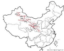
The journey normally runs between Xining, the capital of Qinghai, and Dunhuang in western Gansu. You can travel it in either direction.
Going west from Xining, the route climbs onto the Tibetan plateau, follows the edge of Qinghai Lake, crosses the salt basin near Golmud, then turns north into the Hexi Corridor and ends at the desert oasis of Dunhuang.
The full distance is roughly 1,100 kilometres. Most itineraries take four to six nights, because the value of this route is in stopping rather than covering ground.
Xining and the start of the plateau
Xining sits at about 2,275 metres. It is the last major city before the plateau proper and has been a trading crossroads for centuries, where Han Chinese, Tibetan, Mongol and Hui cultures meet.
The main site nearby is Kumbum Monastery, also called Ta’er Monastery, one of the most important Tibetan Buddhist monasteries outside Tibet. It is known for its butter sculptures and its gilded roofs.
Give yourself a day here before travelling higher. The altitude gain from sea level is significant, and starting slowly makes the rest of the trip more comfortable.
Qinghai Lake and the grassland
Qinghai Lake is the largest lake in China. It is salty, not fresh, and it sits at roughly 3,200 metres, ringed by grassland and distant snow peaks.
The colour is what people remember. On a clear day the water is a deep blue that looks almost artificial against the yellow grass.
What to look for here:
- Rapeseed fields that flower bright yellow around the lake in July
- Bird Island, an important migratory bird site on the western shore
- Nomadic herding culture, with yaks and sheep grazing right up to the shoreline
- Prayer flags and stupas at viewpoints around the lake
The wind is constant and the air is thin, so even in summer it feels cool early and late in the day.
The salt basin
West of the lake, the landscape changes completely. The grass thins out and the route crosses the Qaidam Basin, a vast high desert of salt flats and mineral lakes.
The salt lakes here are the visual highlight of the middle section. When conditions are right, a shallow film of water sits over the salt crust and reflects the sky, so the ground and the horizon blur together. Photographers plan whole trips around it.
Golmud is the main town in this area. It is functional rather than beautiful, but it is the supply centre for the whole basin and a junction point for routes heading toward Tibet.
Into the Hexi Corridor
North of the basin, the route enters Gansu and the Hexi Corridor, a narrow strip of habitable land squeezed between the Qilian Mountains and the Gobi Desert.
This corridor is the reason the Silk Road existed in the form it did. It was the only practical way to move goods west, so whoever controlled it controlled the trade. That is why the Great Wall was extended along it and why forts and beacon towers still stand at intervals across the desert.
Depending on the itinerary, this section may include stops in the wider Gansu region, which is known for its striped rock formations, its Great Wall fortifications and its long history as a military frontier. Check the specific departure to see which excursions are included.
Dunhuang: the main event
Most people travel this route for Dunhuang, and it deserves the reputation.
The Mogao Caves are a complex of hundreds of Buddhist grottoes cut into a cliff face, decorated with wall paintings and statues created over roughly a thousand years. It is one of the most important collections of Buddhist art anywhere. Visitor numbers are limited by a daily quota and photography inside the caves is not permitted, so book well in advance.
Singing Sand Mountain, or Mingsha Shan, is a range of enormous dunes on the edge of town. The name comes from the sound the sand makes as it shifts. Camel rides across the dunes are the classic activity, best at sunrise or sunset.
Crescent Moon Spring, or Yueyaquan, is a small curved lake sitting in a hollow between the dunes, with a temple beside it. It has survived in the desert for centuries and is one of the most photographed places in China.
Yangguan and Yumen Passes lie further out into the desert. These were the frontier gates of the Han empire, the point where travellers settled China behind. Little remains beyond ruined watchtowers and open gravel plain, but the sense of standing at an edge is strong.
How to travel the route
Scheduled trains. Regular services connect the cities along the way. This is cheap and flexible, but you will need to book tickets in advance, arrange your own hotels in each town, and organise transport out to the sites, which are often well outside the towns.
Private tourist train. A packaged option runs this section in both directions, with cabins, meals, guides and excursions included. The Xining to Dunhuang train journey uses this format, so you sleep on board and travel overnight between locations rather than changing hotels.
Road trip. Driving gives the most freedom and lets you stop anywhere, but the distances are long and some sections are remote with limited services.
Altitude and how to handle it
This route takes real time above 3,000 metres, so it is worth taking seriously without worrying about it.
Simple precautions help:
- Rest on your first day in Xining rather than starting immediately
- Drink more water than usual, since the air is very dry
- Go easy on alcohol for the first day or two
- Walk slowly at the high viewpoints
- Keep a warm layer with you even on hot days
Mild headache, tiredness or shortness of breath are common and usually pass. If you have heart or lung conditions, or you are unsure, speak to your doctor before booking.
Best time to go
| Season | Conditions | Verdict |
| April to May | Cool, dry, quiet, some sand and dust | Good, pack warm layers |
| June to August | Green grassland, rapeseed in flower, busy and hot in the desert | Peak season, book early |
| September to October | Clear skies, comfortable temperatures, autumn colour | Best overall |
| November to March | Very cold, reduced services, empty sites | For hardy travellers only |
September is the strongest single choice. The summer crowds have thinned, the light is clear for photography, and temperatures are comfortable in both the plateau and the desert sections.
Common questions
How long does the journey take? Four to six nights is normal if you want to stop properly. It can be rushed in less, but you would miss most of the point.
Which direction is better? Both work. Travelling west from Xining builds toward Dunhuang as the finish, which many people prefer. The Dunhuang to Xining route runs the same highlights in reverse and ends on the plateau instead.
Do I need a guide? Not strictly, but sites like the Mogao Caves are far more rewarding with one, and some excursions are easier to arrange through an operator.
Is it suitable for older travellers? Yes, with attention to the altitude. The packaged train option suits older travellers well because it removes repeated packing and long road transfers.
What is the food like? Hand pulled noodles, lamb, and wheat based dishes dominate. Gansu and Qinghai food is hearty and well suited to the climate.
Final thoughts
The Qinghai to Gansu route works because the landscape changes so completely across a short distance. You start on high grassland with yaks and prayer flags, cross a salt desert, and finish at a Buddhist cave complex in the sand.
Plan for the altitude, travel in autumn if you can, and give Dunhuang at least two full days. It is the reason the route exists.